
July 23, 2009, Thursday:
We survived the mosquito spraying last night. About 1:00pm, when the smell was gone, Susie put he fan in the RV window and sucked the cool air inside. Daisy was much happier and so were we. We left Oakwood Lakes at 10:30am and headed southeast into Brookings to visit 2 AAA Gems. The first was McCrory Gardens on the grounds of South Dakota State University. As a matter of fact, all three Gems were on the campus of SDSC. We walked through numerous plantings and landscape features, trying to avoid the irrigation systems that seemed to spray water wherever we stood. As with all gardens, you get what is flowering at the time of the year you are visiting, but I can tell you that there was enough color for sensory overload. From here we headed to the Agriculture Heritage Museum. In this building were several very old tractors, some steam driven others gas driven. It is interesting to see the tools that farmers had available to them in the 1910’s. There was a brief history of the Briggs & Stratton Company. Briggs never went to college, but he had the knack for things mechanical. He eventually left the company and went on to head the Outboard Marine Company. There was another display of farm chores in the 1930’s based on books and illustrations by Bob Artley, born in 1917. If you get chance, look him up on the internet and get one of his books. We bought “Seasons on the Farm”. His work made the display fun, and we noticed several children laughing and wondering was this really how people lived in the 1920’s and 1930’s. As a side note, we were told that we had to go across the street to the Microbiology – Farm building where the students were trying to improve ice cream and create new flavors. We held off on going there and went back to the RV for lunch. After lunch we headed to the South Dakota Art Museum. Many artists with very different stories to tell. From here we went back for ice cream and milk (for me). The ice cream was wonderful and rich, and I needed the milk to wash it down. I returned to the Agriculture Heritage Museum to see if they had any sheets on what SD produced and how it compared with other states. Hooray for the internet, 2 minutes later I had all the info. Returning to the RV, we decided that we would head directly to Pipestone MN and skip Sioux Falls. There was a major reconstruction project on I-29 from Brookings south, creating single land traffic flows. We were on it only for about 10 miles before we exited and headed east into MN. Gabby Garmin was wrong again as we tried to get to Pipestone NM from town, but eventually we figured it out. We checked in to a Campground nearby where Susie gave me a much needed haircut, and we had dinner of hamburgers and corn plus we washed a few loads of stuff, mostly covers for Daisy’s bed. This seems to be a friendly campground with people wandering around and talking with each other. We went to bed around 11:00pm.
July 24, 2009 Friday:
Daisy and I went for our walk at 7:30am and returned to have a cup of coffee for me and breakfast for Daisy. Susie was up a bit later. We spent a good amount of time discussing what we would see in MN. We have decided to keep to our plan of visiting the outlying parks and special features. We headed off to Pipestone NM and discovered that not only was this a monument to protect the material that the Native-Americans used in the past to make pipes and other objects, but the NPS has taken the opportunity to turn the facility into a study of prairie grasses and how to rid the area of all non-native plants, most brought to the area by settlers. When they started the project of restorative burning, about 1/3rd of the plants were non-native. It seems like a tough task, and we wish them well. We left the NM at 2:00pm after having spent time with a couple who are riding a tandem bicycle across the country, Portland OR to Portland ME. They are stopping at friends and families places as they go. Actually we saw them yesterday Susie at McCrory Gardens and me at the Agriculture Heritage Museum. They are in their mid-50’s and must be retired. She has had both knees replaced, and she says he is due. They stay in hotels or B&B’s so there is no need for them to carry tents and all that other stuff. There are numerous wind turbines in the area. Most are smaller, and so must be older because the new technologies permit larger ones now. We were talking to some people in the campground today who were escort vehicle drivers for turbine blades, which are now 130 feet long. Stay tuned, I’m sure they’ll be longer soon. Once again, this is glacial lake area, and we are seeing numerous lakes, some small and some bigger. It is amazing what glaciers leave as they advance and retreat. We eventually stopped at Silbey Lake SP, approximately 10 miles north of Willmar MN. We were able to get the last spot, for one night due only to a recent cancellation. There is no electric, but we’ll make due. We took a short hike in the park to the top of Mt Tom. It was 2 miles round-trip and had a gigantic net elevation change of 100 feet. At the top of Mt Tom, there is an observation tower that just barely got us over the trees. We took a few pictures and started back. The mosquitoes began to get me as we were walking down and when we returned to the RV, I jumped inside. A bit later Susie came in and said the mosquitoes were gone. I took no chances and put on long pants and a long sleeve shirt before venturing forth. There are numerous dogs and young kids in the campground, all having lots of fun. I wonder what time curfew is here? We had green beans and meatloaf for dinner. Remembering our experience in 2006 returning from Canada where we lost all our venison at the border, we are eating all unlabelled food now. It is going to be a bit warmer tonight because we are nestled in the trees and there is not much airflow.
July 25, 2009 Saturday:
We awoke this morning with cool temperatures, blue skies and wind in the treetops. It wasn’t until Daisy and I went for our walk and got away from the trees that I realized how hard it was blowing. We took showers and because the showers wouldn’t shut off, all the hot water was gone in just a few minutes. A waste of water and electricity. We had eggs, sausage and orange juice for breakfast, cooked on the outside stove. We left the Park at 11:00am and headed north towards Alexandria to visit the Runstone Museum. This museum is primarily dedicated to the discovery in the late 1890’s of a stone with ancient Viking symbols and tools that cast further doubts on the belief that Columbus discovered America. The stone tells the story about the attack and resulting death of some of their comrades while in MN. I had known since 2006 that there are the remains of a Viking settlement on the northwest corner of Newfoundland. We had wanted to go there, but ran out of time. Also Jared Diamond’s latest book “Collapse” in which he discusses Vikings in Greenland and there adventures further west. It seems very possible that they sailed into Hudson Bay, walked upstream to Lake Winnipeg and walked further south into Minnesota. According to information in the Museum, the authenticity of the stone has become more certain as investigative technology has become more sophisticated. There were other exhibits, and the one that sticks with Susie and me is a story written by a man and his experiences as a boy with the old (pre-rotary dial) telephones and “Information, Please”. He thought there was a wonderfully smart lady inside the phone who would answer any question he had. He asked her how to spell words, help with homework, etc. Even after the boy was grown, he kept it touch and was devastated he called and she had died. However, the lady had left a note with the other operators, and it was read to him. That softened the blow. After we left the Museum, we went to the local bakery for bread, an éclair and napoleon for a treat. We then continued on north, but were going to take a detour along a route marked as scenic by Rand McNally. We traveled about 10 miles and realized it wasn’t scenic at all. We took a series of back roads, which were much more scenic and arrived at Itasca SP. There were 3 spots with electricity remaining and we took one for two nights. One again we dodged a bullet. A heavy rainstorm came through and washed the RV. We had internet so I looked at local radar. This was the only precipitation within 100 miles. We noted that this land, while it has different trees than home, has the feel of the east coast with large trees and big woods. There are 11,000+ lakes in Minnesota (no matter what the State license plate says), and everyone seems to have vacation houses. We went to bed early and plan to take the day off tomorrow to relax. Probably won’t be as successful as we believe. Last night we discovered that I had forgotten to fill the RV water tank, and it was empty. That was a first, and something we’ll have to remedy.
July 26, 2009 Sunday:
Today was a bit of a rest day, and we enjoyed it. About 11:00am we decided that we should ride our bikes to the Headwaters of the Mississippi River, the outflow from Lake Itasca, and then continue around Lake Itasca, a distance of approximately 15 miles. The Minnesota folks said it was a bit hilly, but we weren’t worried. Susie made a lunch and off we went. The place was full of people of all ages. The youngest was a 19-day old, and the oldest, who knows. Kids, adults and dogs were all in the water, and it was easy to walk across the Mississippi as it was only 18” deep at worst. As we watched, the scene reminded us of the one at Upper Emerald Pool in Zion NP a couple of months ago. We finally left and went to the Visitor Center to have lunch and buy a commemorative pin for the Headwaters and the State Park. Off we went around the Lake in a counterclockwise direction. For a while the road was 2-way, but soon it became one-way and less stressful. Up and down small hills without any trouble. We stopped to see an Eastern White Pine Tree that was more than 300 years old. It was in good health. We continued on, but noticed that every time we stopped, the mosquitoes and deerflies swarmed and bit. Back on the bikes. And we stopped again to see a 300+ year-old Red Pine. It was not as healthy as the Eastern White Pine, but it had the distinction of being the co-holder champion of being the biggest Red Pine in the USA. We kept on going and returned to the RV around 4:00pm. Showers were in order and then a quick steak, potatoes and cooked carrot dinner. We unhooked the RV and drove to listen to a trio of local singers, Alabaster Falls. They were wonderful and most everyone stayed for the entire 2-hour show. We returned to the Campground and did some computer work. I was working in iPhoto and noticed for the 2nd time in the last few days that photos had disappeared from iPhoto but not from the hard drive. What a stressful time! I finally just went to bed and hoped that they would re-appear tomorrow.
July 27, 2009 Monday:
Daisy and I took our walk this morning, and she was a bit perky. Susie was drawing and I working on downloading my blog. Something bad seemed to have happened there also, and I hope I was able to fix it. We took showers and left the Park at 11:45am. We headed northeast east on US71 to International Falls. The road was often straight as an arrow as it tracked across the gently rolling hills on MN. I commented to Susie that if there were no trees, we would be able to see for miles. This area had been heavily logged in the early 1900’s, and it has been slow to recover. However, there now seems to be a plan and the timber industry is slowly coming back. The trees do not grow as fast as they do in the warmer climate, but they are making progress. The winds were blowing hard all day, making the driving a bit tough at times. We arrived in International Falls and immediately stopped at the Visitor Center in hopes of find material on Voyagers NP. Susie was successful, and we then shopped for groceries, gas and a place to stay. We found a small RV Park and settled in. I spent a time trying to figure out how to take the Boise Cascade Paper Plant tour and see as much of Voyagers NP as possible. I think we have it under control, but I need to call the tour boat company to see if the published schedule is the correct one. I have an inkling from our neighbors that it may not be. Our neighbors have an older RV, and while talking with them, realized that this is their send one, the first having been junked after 220,000 miles. On that basis, ours is just broken in. I talked to them about our battery problem without coming up with a solution. He told me that he had added more metering of the electric system so that he could tell more accurately what the charge levels were. We’re going to be able to get back home without too much inconvenience. I am actually more worried about my computer and all the photographs. We had a thunderstorm, but later the weather cleared.
July 28, 2009 Tuesday
The weather was wet, cloudy, windy and raw, just like a fall day at home. Having hot cereal for breakfast pretty much says it all! It pretty much stayed that way all day. We toured the Boise paper mill from 11:00am to 12:15pm. Two financial businessmen took the company Boise Cascade private from the country of India a few years ago. The papermaking process started with the delivery of logs from the 335,000 acres of land owned by Boise in Minnesota. The bark is stripped from the logs and used to generated heat for drying the paper pulp. The logs are chipped and turned into pulp in vats that are about 10 feet in diameter and 15 feet deep. From the vat the highly diluted pulp is distributed on to a fine meshed fabric. The water is drawn away, and all that is left is the continuous moving fiber mat. This mat, or sheet, then enters the drying section where steam heated cylinders evaporate most of the remaining water, and then heavy steel rollers finish the sheet to the required thickness and smoothness. On the smaller of the paper machines, the sheet moves at 29mph, and on the biggest machine (cost $525M) the paper moves at 41mph. The most exciting time is when there is a weak point in the paper, causing it to break. The machines shuts down automatically but just visualize the mess created by 40 -foot wide sheet of pulp/paper traveling wild at 41mph (60 feet/sec). This happens 2 to 3 times per 24-hour period. We just missed seeing this happen on the big machine, but we did see the wet mess on the floor. The cutting of the paper, wrapping and boxing the product were fun to watch, but I just kept thinking that it takes us about 15 months to go through one box. Not all of the boxes had Boise labels, there were some from Staples and other companies I did not recognize. So the lesson is to buy the weight and color you want at the cheapest price. It is probably the same paper as the most expensive brand. We drove to the Rainy Lake Visitor Center of Voyagers National Park. This entrance is at the west end and closest to International Falls. We were able to get reservations on 2 boat tours for tomorrow afternoon, leaving from RLVC, and then another trip on Thursday from Kabetogama Lake Visitor Center on Thursday afternoon. Susie and I think that we’ll get a much better view and understanding of the Park looking from the water. After all, 38.5% of the area of the Park is water. There are wolves in the Park, but the Ranges didn’t seem to know how many or where. Minnesota has not imported wolves, as has Yellowstone NP, all are native. We watched 2 movies and took a short hike before returning to the RV Park, the same one we were stayed in last night. It rained a bit as soon as we were tucked in, and we hope that tomorrow will be better. At least we have good wet weather gear for the boat trips.
July 29, 2009 Wednesday:
This morning was a it colder, but there were signs of sun coming through the clouds. NOAA still is forecasting 20% chance of rain and thunderstorms for the next 4 days. Susie took pictures of her drawings, and I prepared the RV to go to the Rainy Lake Visitor Center to take 2 boat tours. The boat was a pontoon boat with a seating capacity of 20+ people and was named the Borealis.
As I said yesterday, we thought that the way to see this Park is by water, and we were correct. We saw the western part today and will see the eastern part tomorrow. There were numerous houseboats, mostly rental we suspect, cruising around or moored to the shore. The more fancy houseboats have waterslides and hot tubs. We were told that the Park has 204 campsites that are accessible only by water and maybe 30% were in use. It is ‘first come, first served’ for all these sites, and there were numerous kayaks and canoes pulled ashore at them. I am sure the Park is almost full during the weekends. We had a brief tour of Little American Island, the largest gold mine in the area. The gold rush went bust in ????years, but the remains of the shafts and tailing still remain. What we have seen so far reminds me of the San Juan Islands in WA, the 1,000 Islands and Adirondack Park in NY. This is much smaller, but it gives me a sense of peace as we traveled across the water.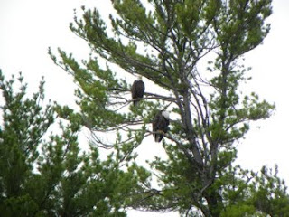
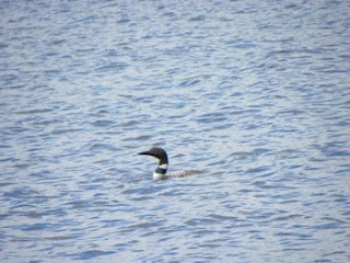
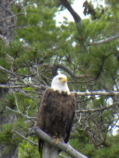 By the way, we learned that MN has 11,864 lakes, according to the National Park Service. I wonder how big a piece of water needs to qualify as a lake? We saw numerous bald eagles, but the young have not yet fledged. There are 36 nesting pair of bald eagles in the Park, about as much as it can support so now the population is spreading in all directions beyond the Park borders. We saw a family of Loons: mother, father and one chick. The parents were teaching the chick how to dive and fish for dinner. Every so often we would hear the mother and father calling to each other with their wonderful song. We saw a single large turtle, about 12” in diameter, slip from a rock and disappear into the water.
 I thought that the Rainy River, which flows through International Falls, flowed east into Lake Superior, but the Ranger corrected me. After a bit of investigation, I found that one the border between the US and Canada sits Moose Mountain (about 35 miles from Lake Superior). The water that flows down the east side of the mountain flows into Lake Superior and eventually to the Atlantic Ocean. The water that flows down the west side flows west through Voyagers NP, down the Rainy River to the Lake of the Woods in Canada and eventually empties into Hudson Bay. So now we know that water flows 2 directions in MN, but let’s add a third, the water that flow down the Mississippi River to the Gulf of Mexico. A look at a National Geographic Hydrological Map of North America indicates that this is the only state that has water flowing to 3 different drainage basins. We finished the 2nd boat tour at 5:00pm, loaded the RV and headed east to the Woodenfrog Campground, a MN State Forest campground, near the VNP Kabetogama Visitor Center from where we’ll take our tour of the eastern portion of the Park to Kettle Falls Hotel (accessible only by water). It rained a bit as the sun went down.
We survived the mosquito spraying last night. About 1:00pm, when the smell was gone, Susie put he fan in the RV window and sucked the cool air inside. Daisy was much happier and so were we. We left Oakwood Lakes at 10:30am and headed southeast into Brookings to visit 2 AAA Gems. The first was McCrory Gardens on the grounds of South Dakota State University. As a matter of fact, all three Gems were on the campus of SDSC. We walked through numerous plantings and landscape features, trying to avoid the irrigation systems that seemed to spray water wherever we stood. As with all gardens, you get what is flowering at the time of the year you are visiting, but I can tell you that there was enough color for sensory overload. From here we headed to the Agriculture Heritage Museum. In this building were several very old tractors, some steam driven others gas driven. It is interesting to see the tools that farmers had available to them in the 1910’s. There was a brief history of the Briggs & Stratton Company. Briggs never went to college, but he had the knack for things mechanical. He eventually left the company and went on to head the Outboard Marine Company. There was another display of farm chores in the 1930’s based on books and illustrations by Bob Artley, born in 1917. If you get chance, look him up on the internet and get one of his books. We bought “Seasons on the Farm”. His work made the display fun, and we noticed several children laughing and wondering was this really how people lived in the 1920’s and 1930’s. As a side note, we were told that we had to go across the street to the Microbiology – Farm building where the students were trying to improve ice cream and create new flavors. We held off on going there and went back to the RV for lunch. After lunch we headed to the South Dakota Art Museum. Many artists with very different stories to tell. From here we went back for ice cream and milk (for me). The ice cream was wonderful and rich, and I needed the milk to wash it down. I returned to the Agriculture Heritage Museum to see if they had any sheets on what SD produced and how it compared with other states. Hooray for the internet, 2 minutes later I had all the info. Returning to the RV, we decided that we would head directly to Pipestone MN and skip Sioux Falls. There was a major reconstruction project on I-29 from Brookings south, creating single land traffic flows. We were on it only for about 10 miles before we exited and headed east into MN. Gabby Garmin was wrong again as we tried to get to Pipestone NM from town, but eventually we figured it out. We checked in to a Campground nearby where Susie gave me a much needed haircut, and we had dinner of hamburgers and corn plus we washed a few loads of stuff, mostly covers for Daisy’s bed. This seems to be a friendly campground with people wandering around and talking with each other. We went to bed around 11:00pm.
July 24, 2009 Friday:
Daisy and I went for our walk at 7:30am and returned to have a cup of coffee for me and breakfast for Daisy. Susie was up a bit later. We spent a good amount of time discussing what we would see in MN. We have decided to keep to our plan of visiting the outlying parks and special features. We headed off to Pipestone NM and discovered that not only was this a monument to protect the material that the Native-Americans used in the past to make pipes and other objects, but the NPS has taken the opportunity to turn the facility into a study of prairie grasses and how to rid the area of all non-native plants, most brought to the area by settlers. When they started the project of restorative burning, about 1/3rd of the plants were non-native. It seems like a tough task, and we wish them well. We left the NM at 2:00pm after having spent time with a couple who are riding a tandem bicycle across the country, Portland OR to Portland ME. They are stopping at friends and families places as they go. Actually we saw them yesterday Susie at McCrory Gardens and me at the Agriculture Heritage Museum. They are in their mid-50’s and must be retired. She has had both knees replaced, and she says he is due. They stay in hotels or B&B’s so there is no need for them to carry tents and all that other stuff. There are numerous wind turbines in the area. Most are smaller, and so must be older because the new technologies permit larger ones now. We were talking to some people in the campground today who were escort vehicle drivers for turbine blades, which are now 130 feet long. Stay tuned, I’m sure they’ll be longer soon. Once again, this is glacial lake area, and we are seeing numerous lakes, some small and some bigger. It is amazing what glaciers leave as they advance and retreat. We eventually stopped at Silbey Lake SP, approximately 10 miles north of Willmar MN. We were able to get the last spot, for one night due only to a recent cancellation. There is no electric, but we’ll make due. We took a short hike in the park to the top of Mt Tom. It was 2 miles round-trip and had a gigantic net elevation change of 100 feet. At the top of Mt Tom, there is an observation tower that just barely got us over the trees. We took a few pictures and started back. The mosquitoes began to get me as we were walking down and when we returned to the RV, I jumped inside. A bit later Susie came in and said the mosquitoes were gone. I took no chances and put on long pants and a long sleeve shirt before venturing forth. There are numerous dogs and young kids in the campground, all having lots of fun. I wonder what time curfew is here? We had green beans and meatloaf for dinner. Remembering our experience in 2006 returning from Canada where we lost all our venison at the border, we are eating all unlabelled food now. It is going to be a bit warmer tonight because we are nestled in the trees and there is not much airflow.
July 25, 2009 Saturday:
We awoke this morning with cool temperatures, blue skies and wind in the treetops. It wasn’t until Daisy and I went for our walk and got away from the trees that I realized how hard it was blowing. We took showers and because the showers wouldn’t shut off, all the hot water was gone in just a few minutes. A waste of water and electricity. We had eggs, sausage and orange juice for breakfast, cooked on the outside stove. We left the Park at 11:00am and headed north towards Alexandria to visit the Runstone Museum. This museum is primarily dedicated to the discovery in the late 1890’s of a stone with ancient Viking symbols and tools that cast further doubts on the belief that Columbus discovered America. The stone tells the story about the attack and resulting death of some of their comrades while in MN. I had known since 2006 that there are the remains of a Viking settlement on the northwest corner of Newfoundland. We had wanted to go there, but ran out of time. Also Jared Diamond’s latest book “Collapse” in which he discusses Vikings in Greenland and there adventures further west. It seems very possible that they sailed into Hudson Bay, walked upstream to Lake Winnipeg and walked further south into Minnesota. According to information in the Museum, the authenticity of the stone has become more certain as investigative technology has become more sophisticated. There were other exhibits, and the one that sticks with Susie and me is a story written by a man and his experiences as a boy with the old (pre-rotary dial) telephones and “Information, Please”. He thought there was a wonderfully smart lady inside the phone who would answer any question he had. He asked her how to spell words, help with homework, etc. Even after the boy was grown, he kept it touch and was devastated he called and she had died. However, the lady had left a note with the other operators, and it was read to him. That softened the blow. After we left the Museum, we went to the local bakery for bread, an éclair and napoleon for a treat. We then continued on north, but were going to take a detour along a route marked as scenic by Rand McNally. We traveled about 10 miles and realized it wasn’t scenic at all. We took a series of back roads, which were much more scenic and arrived at Itasca SP. There were 3 spots with electricity remaining and we took one for two nights. One again we dodged a bullet. A heavy rainstorm came through and washed the RV. We had internet so I looked at local radar. This was the only precipitation within 100 miles. We noted that this land, while it has different trees than home, has the feel of the east coast with large trees and big woods. There are 11,000+ lakes in Minnesota (no matter what the State license plate says), and everyone seems to have vacation houses. We went to bed early and plan to take the day off tomorrow to relax. Probably won’t be as successful as we believe. Last night we discovered that I had forgotten to fill the RV water tank, and it was empty. That was a first, and something we’ll have to remedy.
July 26, 2009 Sunday:
Today was a bit of a rest day, and we enjoyed it. About 11:00am we decided that we should ride our bikes to the Headwaters of the Mississippi River, the outflow from Lake Itasca, and then continue around Lake Itasca, a distance of approximately 15 miles. The Minnesota folks said it was a bit hilly, but we weren’t worried. Susie made a lunch and off we went. The place was full of people of all ages. The youngest was a 19-day old, and the oldest, who knows. Kids, adults and dogs were all in the water, and it was easy to walk across the Mississippi as it was only 18” deep at worst. As we watched, the scene reminded us of the one at Upper Emerald Pool in Zion NP a couple of months ago. We finally left and went to the Visitor Center to have lunch and buy a commemorative pin for the Headwaters and the State Park. Off we went around the Lake in a counterclockwise direction. For a while the road was 2-way, but soon it became one-way and less stressful. Up and down small hills without any trouble. We stopped to see an Eastern White Pine Tree that was more than 300 years old. It was in good health. We continued on, but noticed that every time we stopped, the mosquitoes and deerflies swarmed and bit. Back on the bikes. And we stopped again to see a 300+ year-old Red Pine. It was not as healthy as the Eastern White Pine, but it had the distinction of being the co-holder champion of being the biggest Red Pine in the USA. We kept on going and returned to the RV around 4:00pm. Showers were in order and then a quick steak, potatoes and cooked carrot dinner. We unhooked the RV and drove to listen to a trio of local singers, Alabaster Falls. They were wonderful and most everyone stayed for the entire 2-hour show. We returned to the Campground and did some computer work. I was working in iPhoto and noticed for the 2nd time in the last few days that photos had disappeared from iPhoto but not from the hard drive. What a stressful time! I finally just went to bed and hoped that they would re-appear tomorrow.
July 27, 2009 Monday:
Daisy and I took our walk this morning, and she was a bit perky. Susie was drawing and I working on downloading my blog. Something bad seemed to have happened there also, and I hope I was able to fix it. We took showers and left the Park at 11:45am. We headed northeast east on US71 to International Falls. The road was often straight as an arrow as it tracked across the gently rolling hills on MN. I commented to Susie that if there were no trees, we would be able to see for miles. This area had been heavily logged in the early 1900’s, and it has been slow to recover. However, there now seems to be a plan and the timber industry is slowly coming back. The trees do not grow as fast as they do in the warmer climate, but they are making progress. The winds were blowing hard all day, making the driving a bit tough at times. We arrived in International Falls and immediately stopped at the Visitor Center in hopes of find material on Voyagers NP. Susie was successful, and we then shopped for groceries, gas and a place to stay.
 We found a small RV Park and settled in. I spent a time trying to figure out how to take the Boise Cascade Paper Plant tour and see as much of Voyagers NP as possible. I think we have it under control, but I need to call the tour boat company to see if the published schedule is the correct one. I have an inkling from our neighbors that it may not be. Our neighbors have an older RV, and while talking with them, realized that this is their send one, the first having been junked after 220,000 miles. On that basis, ours is just broken in. I talked to them about our battery problem without coming up with a solution. He told me that he had added more metering of the electric system so that he could tell more accurately what the charge levels were. We’re going to be able to get back home without too much inconvenience. I am actually more worried about my computer and all the photographs. We had a thunderstorm, but later the weather cleared.
July 28, 2009 Tuesday
The weather was wet, cloudy, windy and raw, just like a fall day at home. Having hot cereal for breakfast pretty much says it all! It pretty much stayed that way all day. We toured the Boise paper mill from 11:00am to 12:15pm. Two financial businessmen took the company Boise Cascade private from the country of India a few years ago. The papermaking process started with the delivery of logs from the 335,000 acres of land owned by Boise in Minnesota. The bark is stripped from the logs and used to generated heat for drying the paper pulp. The logs are chipped and turned into pulp in vats that are about 10 feet in diameter and 15 feet deep. From the vat the highly diluted pulp is distributed on to a fine meshed fabric. The water is drawn away, and all that is left is the continuous moving fiber mat. This mat, or sheet, then enters the drying section where steam heated cylinders evaporate most of the remaining water, and then heavy steel rollers finish the sheet to the required thickness and smoothness. On the smaller of the paper machines, the sheet moves at 29mph, and on the biggest machine (cost $525M) the paper moves at 41mph. The most exciting time is when there is a weak point in the paper, causing it to break. The machines shuts down automatically but just visualize the mess created by 40 -foot wide sheet of pulp/paper traveling wild at 41mph (60 feet/sec). This happens 2 to 3 times per 24-hour period. We just missed seeing this happen on the big machine, but we did see the wet mess on the floor. The cutting of the paper, wrapping and boxing the product were fun to watch, but I just kept thinking that it takes us about 15 months to go through one box. Not all of the boxes had Boise labels, there were some from Staples and other companies I did not recognize. So the lesson is to buy the weight and color you want at the cheapest price. It is probably the same paper as the most expensive brand. We drove to the Rainy Lake Visitor Center of Voyagers National Park. This entrance is at the west end and closest to International Falls. We were able to get reservations on 2 boat tours for tomorrow afternoon, leaving from RLVC, and then another trip on Thursday from Kabetogama Lake Visitor Center on Thursday afternoon. Susie and I think that we’ll get a much better view and understanding of the Park looking from the water. After all, 38.5% of the area of the Park is water. There are wolves in the Park, but the Ranges didn’t seem to know how many or where. Minnesota has not imported wolves, as has Yellowstone NP, all are native. We watched 2 movies and took a short hike before returning to the RV Park, the same one we were stayed in last night. It rained a bit as soon as we were tucked in, and we hope that tomorrow will be better. At least we have good wet weather gear for the boat trips.
July 29, 2009 Wednesday:
This morning was a it colder, but there were signs of sun coming through the clouds. NOAA still is forecasting 20% chance of rain and thunderstorms for the next 4 days. Susie took pictures of her drawings, and I prepared the RV to go to the Rainy Lake Visitor Center to take 2 boat tours. The boat was a pontoon boat with a seating capacity of 20+ people and was named the Borealis.

As I said yesterday, we thought that the way to see this Park is by water, and we were correct. We saw the western part today and will see the eastern part tomorrow. There were numerous houseboats, mostly rental we suspect, cruising around or moored to the shore. The more fancy houseboats have waterslides and hot tubs. We were told that the Park has 204 campsites that are accessible only by water and maybe 30% were in use. It is ‘first come, first served’ for all these sites, and there were numerous kayaks and canoes pulled ashore at them. I am sure the Park is almost full during the weekends. We had a brief tour of Little American Island, the largest gold mine in the area. The gold rush went bust in ????years, but the remains of the shafts and tailing still remain. What we have seen so far reminds me of the San Juan Islands in WA, the 1,000 Islands and Adirondack Park in NY. This is much smaller, but it gives me a sense of peace as we traveled across the water.

 By the way, we learned that MN has 11,864 lakes, according to the National Park Service. I wonder how big a piece of water needs to qualify as a lake? We saw numerous bald eagles, but the young have not yet fledged. There are 36 nesting pair of bald eagles in the Park, about as much as it can support so now the population is spreading in all directions beyond the Park borders. We saw a family of Loons: mother, father and one chick. The parents were teaching the chick how to dive and fish for dinner. Every so often we would hear the mother and father calling to each other with their wonderful song. We saw a single large turtle, about 12” in diameter, slip from a rock and disappear into the water.

 I thought that the Rainy River, which flows through International Falls, flowed east into Lake Superior, but the Ranger corrected me. After a bit of investigation, I found that one the border between the US and Canada sits Moose Mountain (about 35 miles from Lake Superior). The water that flows down the east side of the mountain flows into Lake Superior and eventually to the Atlantic Ocean. The water that flows down the west side flows west through Voyagers NP, down the Rainy River to the Lake of the Woods in Canada and eventually empties into Hudson Bay. So now we know that water flows 2 directions in MN, but let’s add a third, the water that flow down the Mississippi River to the Gulf of Mexico. A look at a National Geographic Hydrological Map of North America indicates that this is the only state that has water flowing to 3 different drainage basins. We finished the 2nd boat tour at 5:00pm, loaded the RV and headed east to the Woodenfrog Campground, a MN State Forest campground, near the VNP Kabetogama Visitor Center from where we’ll take our tour of the eastern portion of the Park to Kettle Falls Hotel (accessible only by water). It rained a bit as the sun went down.


